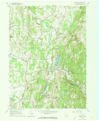
1963 Map of Clermont
USGS Topo · Published 1973About this map
Roeliff Jansen Kill winds through the heart of the Hudson Valley on this survey, defining the agrarian and industrial boundary between Columbia and Dutchess Counties. The landscape is dotted with historic hamlets and mill sites, from the northern cluster at Bingham Mills and Blue Store to the southern reaches of Upper Red Hook and Red Hook Mills. Significant family estates and early settlements are connected by a network of established roads like Hillsdale Rd and Lasher Avenue, while the Taconic State Parkway cuts a modern path through the eastern highlands. Local landmarks such as St Johns Ch in Manorton and the water bodies of Twin Lakes and Warackamac Lake reflect a region defined by its rural heritage and early New York manor history.
Find a feature on this map
46 named features on this map. Tap any name to fly to it.
Don’t see what you’re looking for? This feature index may not catch every label — zoom into the map to look around manually.
Map Details
Editions of this 1963 Clermont Map
4 editions found
Other maps of this area

1895 · Catskill
USGS Topo · 1:62,500

1898 · Rhinebeck
USGS Topo · 1:62,500

1899 · Millbrook
USGS Topo · 1:62,500

1902 · Millbrook
USGS Topo · 1:62,500

1902 · Copake
USGS Topo · 1:62,500

1904 · Copake
USGS Topo · 1:62,500

1934 · Rhinebeck
USGS Topo · 1:48,000

1934 · Catskill
USGS Topo · 1:62,500

1938 · Catskill
USGS Topo · 1:62,500

1939 · Rhinebeck
USGS Topo · 1:62,500