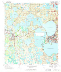
1969 Map of Clermont West
USGS Topo · Published 1971About this map
Clermont and Groveland anchor this 1969 topographic portrait, which details a landscape defined by an extensive chain of lakes connected by the Palatlakaha River. The region's transport and industry are evident through the Seaboard Coast Line railroad and the presence of scattered claypits, while the local community life is marked by sites like the Greenwood Cem and Edgewood Sch. To the west, Mascotte sits near Dukes Cem, surrounded by numerous water bodies including Lake Emma and Lake Lucy.
Find a feature on this map
73 named features on this map. Tap any name to fly to it.
Don’t see what you’re looking for? This feature index may not catch every label — zoom into the map to look around manually.
Map Details
Editions of this 1969 Clermont West Map
2 editions found
Other maps of this area

1955 · Orlando
USGS Topo · 1:250,000

1957 · Orlando
USGS Topo · 1:250,000

1958 · Orlando
USGS Topo · 1:250,000

1959 · Lake Nellie
USGS Topo · 1:24,000

1959 · Lake Louisa
USGS Topo · 1:24,000
1960 · Bay Lake
USGS Topo · 1:24,000

1962 · Orlando
USGS Topo · 1:250,000

1962 · Clermont East
USGS Topo · 1:24,000

1962 · Astatula
USGS Topo · 1:24,000
1969 · Center Hill
USGS Topo · 1:24,000