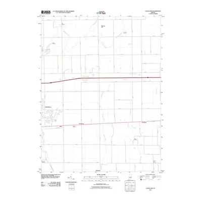
2010 Map of Cleveland
USGS Topo · Published 2010About this map
Brandywine Creek and its many tributaries, including Nameless Creek and Little Brandywine Creek, carve through the structured grid of Hancock County’s agricultural landscape. The map shows the eastern edge of Greenfield and small crossroads like Stringtown and Riley, illustrating how mid-century residential growth began to interface with traditional farmsteads. For genealogists, the landscape is dotted with ancestral burial grounds such as Pratt Cemetery, Barrett Cemetery, and Simmons Cemetery, often situated near the meandering watercourses that likely influenced early settlement patterns. Aviation history is noted by the presence of Pope Field, while the Pennsy Trl follows a decommissioned rail corridor through the heart of the county. The transition from established rural communities like Westland to the expanding suburban outskirts provides a clear view of Indiana's evolving land use at the start of the 21st century.
Find a feature on this map
60 named features on this map. Tap any name to fly to it.
Don’t see what you’re looking for? This feature index may not catch every label — zoom into the map to look around manually.
Map Details
Editions of this 2010 Cleveland Map
This is the sole edition of this map. No revisions or reprints were ever made.
Other maps of this area

1952 · Greenfield
USGS Topo · 1:24,000

1952 · Fountaintown
USGS Topo · 1:24,000

1952 · Ingalls
USGS Topo · 1:24,000

1953 · Pendleton
USGS Topo · 1:24,000

1953 · Cincinnati
USGS Topo · 1:250,000

1956 · Cleveland
USGS Topo · 1:24,000

1956 · Morristown
USGS Topo · 1:24,000

1957 · Cincinnati
USGS Topo · 1:250,000
1960 · Carthage
USGS Topo · 1:24,000
1960 · Knightstown
USGS Topo · 1:24,000