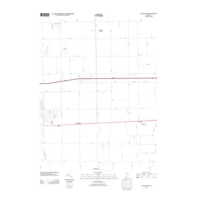
2013 Map of Cleveland
USGS Topo · Published 2013About this map
The settlement of Cleveland anchors this rural landscape, situated along a transportation corridor that bisects the heart of Hancock County. The area is defined by a dense network of creek systems, including Brandywine Cr and Little Brandywine Cr, which weave between small community clusters like Stringtown and Riley. To the north, the Lost Forty Tree Farm and Pleasant Hill represent the agricultural and timber character of the region. The map also highlights two small aviation hubs, Pope Field Airport and Oakes Field Airport, serving local connectivity. The grid of rural roads and the presence of numerous small watercourses such as Dilly Cr, Nameless Cr, and Sixmile Cr illustrate a classic Midwestern drainage and road pattern, where local life follows the subtle contours of the central Indiana plains.
Find a feature on this map
72 named features on this map. Tap any name to fly to it.
Don’t see what you’re looking for? This feature index may not catch every label — zoom into the map to look around manually.
Map Details
Editions of this 2013 Cleveland Map
This is the sole edition of this map. No revisions or reprints were ever made.
Other maps of this area

1952 · Greenfield
USGS Topo · 1:24,000

1952 · Fountaintown
USGS Topo · 1:24,000

1952 · Ingalls
USGS Topo · 1:24,000

1953 · Pendleton
USGS Topo · 1:24,000

1953 · Cincinnati
USGS Topo · 1:250,000

1956 · Cleveland
USGS Topo · 1:24,000

1956 · Morristown
USGS Topo · 1:24,000

1957 · Cincinnati
USGS Topo · 1:250,000
1960 · Carthage
USGS Topo · 1:24,000
1960 · Knightstown
USGS Topo · 1:24,000