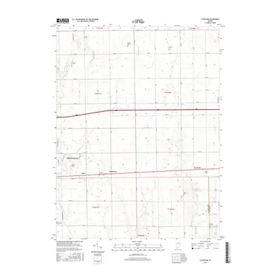
2016 Map of Cleveland
USGS Topo · Published 2016About this map
Greenfield anchors the western edge of this agricultural landscape, where the eastern outskirts of the city meet the rural townships of t16n r7e and t16n r8e. This 2016 survey documents a region defined by a dense grid of county roads and a network of named waterways, including Brandywine Cr and Nameless Cr, which drain the fertile plains. Small settlements and crossroads such as Stringtown, Riley, and Cleveland dot the path of E Main St, tracing the historical corridor of the National Road. The map is particularly useful for genealogical research, as it identifies numerous family and community burial grounds, including the Pratt Cem in the north and the Pleasant View Cem near the Hancock Co Rush Co line. Local aviation is represented by private airstrips like Pope Field and Oakes Field, reflecting the open terrain and decentralized infrastructure of the era.
Find a feature on this map
77 named features on this map. Tap any name to fly to it.
Don’t see what you’re looking for? This feature index may not catch every label — zoom into the map to look around manually.
Map Details
Editions of this 2016 Cleveland Map
This is the sole edition of this map. No revisions or reprints were ever made.
Other maps of this area

1952 · Greenfield
USGS Topo · 1:24,000

1952 · Fountaintown
USGS Topo · 1:24,000

1952 · Ingalls
USGS Topo · 1:24,000

1953 · Pendleton
USGS Topo · 1:24,000

1953 · Cincinnati
USGS Topo · 1:250,000

1956 · Cleveland
USGS Topo · 1:24,000

1956 · Morristown
USGS Topo · 1:24,000

1957 · Cincinnati
USGS Topo · 1:250,000
1960 · Carthage
USGS Topo · 1:24,000
1960 · Knightstown
USGS Topo · 1:24,000