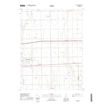
2019 Map of Cleveland
USGS Topo · Published 2019About this map
Greenfield and its eastern neighbor Cleveland anchor this map of central Indiana, where the landscape is defined by the regular grid of the Public Land Survey System and the southern drainage of the White River watershed. The terrain is crisscrossed by several waterways, including Brandywine Cr and Nameless Cr, which influenced the placement of early settlements like Stringtown and Riley. Genealogists will find a wealth of local history in the numerous family and community burial grounds scattered across the townships, such as Baptist Braddock Cem and Hinchman Cem. The area maintains its agricultural character, evidenced by the secondary roads connecting small community hubs like Westland and local landmarks such as Pope Field and Oakes Field. This record shows a modern view of the region, where the traditional rural structure of Hancock Co meets the growing eastern edges of the county seat.
Find a feature on this map
43 named features on this map. Tap any name to fly to it.
Don’t see what you’re looking for? This feature index may not catch every label — zoom into the map to look around manually.
Map Details
Editions of this 2019 Cleveland Map
This is the sole edition of this map. No revisions or reprints were ever made.
Other maps of this area

1952 · Greenfield
USGS Topo · 1:24,000

1952 · Fountaintown
USGS Topo · 1:24,000

1952 · Ingalls
USGS Topo · 1:24,000

1953 · Pendleton
USGS Topo · 1:24,000

1953 · Cincinnati
USGS Topo · 1:250,000

1956 · Cleveland
USGS Topo · 1:24,000

1956 · Morristown
USGS Topo · 1:24,000

1957 · Cincinnati
USGS Topo · 1:250,000
1960 · Carthage
USGS Topo · 1:24,000
1960 · Knightstown
USGS Topo · 1:24,000