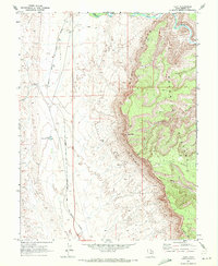
1969 Map of Cliff
USGS Topo · Published 1972About this map
Cliff sits at the base of a dramatic geological transition where the high plateau of the Book Cliffs drops away into the arid basin floor. This 1969 field-checked survey highlights the critical infrastructure required to navigate and survive this eastern Utah environment, notably the Denver and Rio Grande Western railroad corridor. The rail line follows the level terrain west of the escarpment, providing a lifeline through a landscape defined by seasonal water management, as evidenced by Desert Reservoir No 2.
Find a feature on this map
13 named features on this map. Tap any name to fly to it.
Don’t see what you’re looking for? This feature index may not catch every label — zoom into the map to look around manually.
Map Details
Editions of this 1969 Cliff Map
This is the sole edition of this map. No revisions or reprints were ever made.
Other maps of this area

1886 · Price River
USGS Topo · 1:250,000

1896 · Price River
USGS Topo · 1:250,000

1948 · Woodside
USGS Topo · 1:62,500

1949 · Woodside
USGS Topo · 1:62,500

1950 · Woodside
USGS Topo · 1:62,500

1953 · Beckwith Peak SW
USGS Topo · 1:24,000

1954 · Range Creek
USGS Topo · 1:62,500

1956 · Price
USGS Topo · 1:250,000

1960 · Price
USGS Topo · 1:250,000

1962 · Price
USGS Topo · 1:250,000