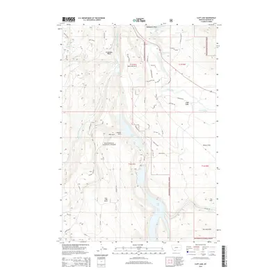
2014 Map of Cliff Lake
USGS Topo · Published 2014About this map
Cliff Lake and Wade Lake dominate this high-altitude landscape within the Beaverhead National Forest, where steep benches and gulches rise from the Madison River valley. The map reveals a remote geography of named homesteads and local landmarks, such as Schusters Place in the north and Grahams Place near Bogus Bench. The area is defined by its drainage systems, including the West Fork Madison River and numerous mountain creeks like Butte Cr and Deadman Cr. A complex network of backcountry routes such as Trumpeter Trl and Gravelly Trl provide access to the high ridges of the Horn Mountains and the expanse of Missouri Flats. This 2014 survey documents the enduring spatial layout of these Forest Service lands, preserving the specific locations of family-named sites and the topographic character of the Wade Lake Bench before further environmental or development changes.
Find a feature on this map
62 named features on this map. Tap any name to fly to it.
Don’t see what you’re looking for? This feature index may not catch every label — zoom into the map to look around manually.
Map Details
Editions of this 2014 Cliff Lake Map
This is the sole edition of this map. No revisions or reprints were ever made.
Other maps of this area

1950 · Cliff Lake
USGS Topo · 1:62,500

1950 · Hebgen Dam
USGS Topo · 1:62,500

1950 · Upper Red Rock Lake
USGS Topo · 1:62,500

1955 · Ashton
USGS Topo · 1:250,000

1958 · Ashton
USGS Topo · 1:250,000

1960 · Ashton
USGS Topo · 1:250,000

1964 · Targhee Peak
USGS Topo · 1:24,000

1964 · Henrys Lake
USGS Topo · 1:62,500
1988 · Granite Mountain
USGS Topo · 1:24,000
1988 · Hidden Lake Bench
USGS Topo · 1:24,000