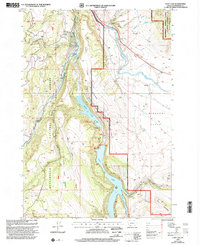
1997 Map of Cliff Lake
USGS Topo · Published 2002About this map
The Madison River snakes through the high-elevation landscape of the Beaverhead National Forest in this late-twentieth-century study of southwestern Montana. The geography is dominated by a chain of glacial lakes, most notably Wade Lake and Cliff Lake, which are separated from the surrounding Missouri Flats by the prominent Wade Lake Bench. Human activity in the area is centered on recreation and resource management, evidenced by Grahams Place, the Wade Lake Resort, and several organized sites like Hilltop Campground and Cliff Point Campground. To the northeast, the Lee Metcalf Wilderness preserves the undisturbed terrain near The Horn and the Horn Mountains. Scattered Gravel Pits and the Pine Butte Lodge further indicate the mix of small-scale industry and tourism that defines this portion of the Madison Ranger District.
Find a feature on this map
34 named features on this map. Tap any name to fly to it.
Don’t see what you’re looking for? This feature index may not catch every label — zoom into the map to look around manually.
Map Details
Editions of this 1997 Cliff Lake Map
This is the sole edition of this map. No revisions or reprints were ever made.
Other maps of this area

1950 · Cliff Lake
USGS Topo · 1:62,500

1950 · Hebgen Dam
USGS Topo · 1:62,500

1950 · Upper Red Rock Lake
USGS Topo · 1:62,500

1955 · Ashton
USGS Topo · 1:250,000

1958 · Ashton
USGS Topo · 1:250,000

1960 · Ashton
USGS Topo · 1:250,000

1964 · Targhee Peak
USGS Topo · 1:24,000

1964 · Henrys Lake
USGS Topo · 1:62,500
1988 · Granite Mountain
USGS Topo · 1:24,000
1988 · Hidden Lake Bench
USGS Topo · 1:24,000