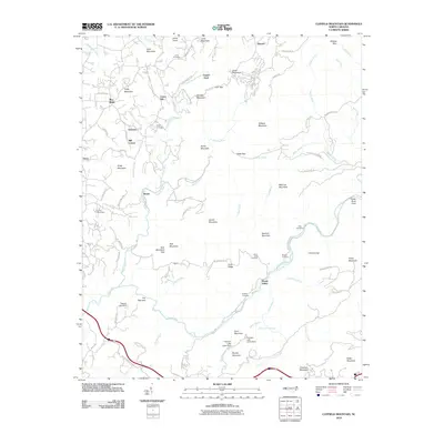
2010 Map of Cliffield Mountain
USGS Topo · Published 2010About this map
Cliffield Mountain and the surrounding Blue Ridge peaks dominate this 2010 topographic study, which tracks the complex drainage systems of the Green River and Hungry River. The landscape is characterized by narrow gaps and high ridges, including Deep Gap and Rich Mountain Gap, which have historically dictated the movement of people and livestock through Henderson County. Small mountain settlements and crossroads like Union Hill, Baxter, and Mill Corner serve as anchors for the local community, while numerous family burying grounds such as Stepp Cemetery and Jones-Price Cemetery offer significant points of interest for genealogists tracing ancestral homesteads. Civil engineering and water management are evident at the Larry Ball Dam and Pegram Lake Dam, alongside natural landmarks like the Bradley Falls waterfall. The network of winding mountain roads, including Old Howard Gap Rd and Big Hungry Rd, follows the difficult contours of the terrain, connecting isolated valleys and summits.
Find a feature on this map
95 named features on this map. Tap any name to fly to it.
Don’t see what you’re looking for? This feature index may not catch every label — zoom into the map to look around manually.
Map Details
Editions of this 2010 Cliffield Mountain Map
This is the sole edition of this map. No revisions or reprints were ever made.
Other maps of this area

1907 · Saluda
USGS Topo · 1:125,000

1935 · Batcave
USGS Topo · 1:24,000

1935 · Hendersonville
USGS Topo · 1:24,000

1935 · Fishtop
USGS Topo · 1:24,000

1935 · Zirconia
USGS Topo · 1:24,000

1936 · Fruitland
USGS Topo · 1:24,000

1942 · Fruitland
USGS Topo · 1:24,000

1946 · Zirconia
USGS Topo · 1:24,000

1946 · Bat Cave
USGS Topo · 1:24,000
1946 · Hendersonville
USGS Topo · 1:24,000