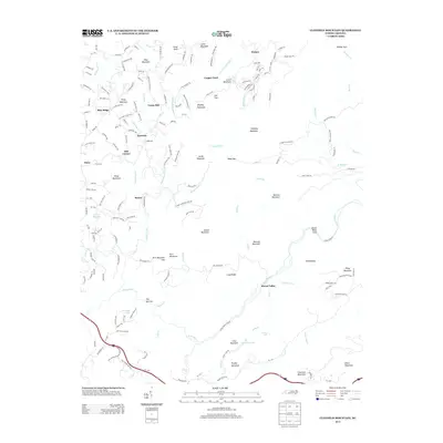
2013 Map of Cliffield Mountain
USGS Topo · Published 2013About this map
Union Hill and Saconon anchor the northern reaches of this Henderson County terrain, where the landscape is defined by the winding course of the Hungry River and its numerous tributaries. The map documents a rural transition where small crossroads settlements like Mill Corner and Baxter sit between the steep slopes of the Blue Ridge and the Green River valley. This 2013 survey captures the complex drainage patterns of the area, including The Narrows and Green River Cove, alongside localized landmarks such as Larry Bull Lake and Pegram Lake. The road network, featuring Union Hill Church Rd and Pilot Mountain Rd, illustrates the persistent mountain topography that has shaped local development for generations. Genealogists and historians can identify family-named peaks like McCraw Mountain and Livert Mountain that characterize the high country between Dana and the remote ridges of Wildcat Spur.
Find a feature on this map
177 named features on this map. Tap any name to fly to it.
Don’t see what you’re looking for? This feature index may not catch every label — zoom into the map to look around manually.
Map Details
Editions of this 2013 Cliffield Mountain Map
This is the sole edition of this map. No revisions or reprints were ever made.
Other maps of this area

1907 · Saluda
USGS Topo · 1:125,000

1935 · Batcave
USGS Topo · 1:24,000

1935 · Hendersonville
USGS Topo · 1:24,000

1935 · Fishtop
USGS Topo · 1:24,000

1935 · Zirconia
USGS Topo · 1:24,000

1936 · Fruitland
USGS Topo · 1:24,000

1942 · Fruitland
USGS Topo · 1:24,000

1946 · Zirconia
USGS Topo · 1:24,000

1946 · Bat Cave
USGS Topo · 1:24,000
1946 · Hendersonville
USGS Topo · 1:24,000