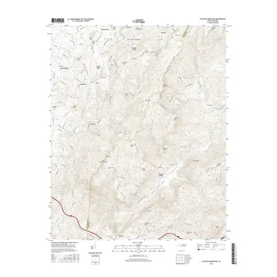
2016 Map of Cliffield Mountain
USGS Topo · Published 2016About this map
The Tennessee Valley Divide snakes across this high-country landscape, where the headwaters of the Hungry River and Green River carve deep into the plateau. The settlement patterns follow the drainages and ridge roads, connecting small mountain communities like Edneyville, Union Hill, and Saconon. Genealogy researchers will find numerous family-named burial sites scattered through the woods, including Stepp Cem, Jones Cem, and Jones-Price Cem. The terrain is marked by significant elevation changes, from the heights of Cliffield Mountain and Lamb Mtn down to the dramatic water features of Stair Step Falls and the constricted passage known as The Narrows. Along the Green River Cove, the transition from upland ridges to riparian lowlands is evident, with the Copper Ford providing a historic crossing point across the upper reaches of the drainage network near the Polk Co line.
Find a feature on this map
153 named features on this map. Tap any name to fly to it.
Don’t see what you’re looking for? This feature index may not catch every label — zoom into the map to look around manually.
Map Details
Editions of this 2016 Cliffield Mountain Map
This is the sole edition of this map. No revisions or reprints were ever made.
Other maps of this area

1907 · Saluda
USGS Topo · 1:125,000

1935 · Batcave
USGS Topo · 1:24,000

1935 · Hendersonville
USGS Topo · 1:24,000

1935 · Fishtop
USGS Topo · 1:24,000

1935 · Zirconia
USGS Topo · 1:24,000

1936 · Fruitland
USGS Topo · 1:24,000

1942 · Fruitland
USGS Topo · 1:24,000

1946 · Zirconia
USGS Topo · 1:24,000

1946 · Bat Cave
USGS Topo · 1:24,000
1946 · Hendersonville
USGS Topo · 1:24,000