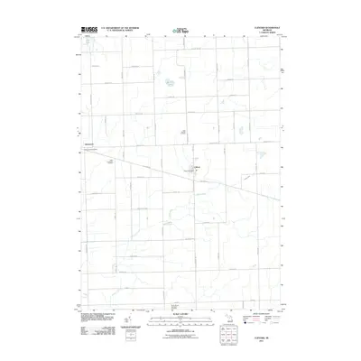
2011 Map of Clifford
USGS Topo · Published 2011About this map
Clifford and Silverwood anchor this part of Lapeer County, where a rigid grid of rural roads connects scattered agricultural lands and small-town centers. The landscape is defined by the winding course of Indian Creek, which cuts diagonally across the southern half of the map, and small water bodies such as Shay Lake and Becroft Lake. For those tracing local history or genealogy, the map identifies essential community landmarks including the Clifford Post Office and Silverwood Post Office. These hubs are complemented by several burial grounds, such as Saint Patricks Cemetery and the West Burlington Cemetery near the village of Silverwood, while the North Branch-Burlington Cemetery marks the southern border. The transition from town to farm is clear through the numerous named roads, from Mayville Rd to Lake Pleasant Rd, showing a settled rural environment where traditional infrastructure remains central to the local geography.
Find a feature on this map
51 named features on this map. Tap any name to fly to it.
Don’t see what you’re looking for? This feature index may not catch every label — zoom into the map to look around manually.
Map Details
Editions of this 2011 Clifford Map
This is the sole edition of this map. No revisions or reprints were ever made.
Other maps of this area

1954 · Flint
USGS Topo · 1:250,000

1958 · Flint
USGS Topo · 1:250,000

1963 · Clifford
USGS Topo · 1:24,000

1963 · East Dayton
USGS Topo · 1:24,000

1963 · Mayville
USGS Topo · 1:24,000

1963 · Marlette
USGS Topo · 1:24,000

1963 · North Branch
USGS Topo · 1:24,000

1963 · Kingston
USGS Topo · 1:24,000

1963 · Burnside
USGS Topo · 1:24,000
1963 · Decker
USGS Topo · 1:24,000