
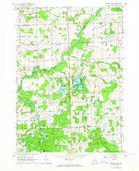
1963 Map of Mayville
USGS Topo · Published 1964About this map
Mayville serves as the central hub of this agricultural and industrial landscape on the border of Tuscola and Lapeer counties. The Chesapeake and Ohio railroad cuts through the terrain, connecting the town to the smaller community of Fostoria to the southwest and Silverwood to the east. The landscape is heavily defined by a complex drainage system, including the North Branch County Drain, Cheeney Drain, and Evergreen Creek, which navigate a low-lying area dotted with small water bodies like Squaw Lake and Dollar Lake.
Find a feature on this map
59 named features on this map. Tap any name to fly to it.
Don’t see what you’re looking for? This feature index may not catch every label — zoom into the map to look around manually.
Map Details
Editions of this 1963 Mayville Map
This is the sole edition of this map. No revisions or reprints were ever made.
Other maps of this area

1954 · Flint
USGS Topo · 1:250,000

1958 · Flint
USGS Topo · 1:250,000

1963 · Clifford
USGS Topo · 1:24,000

1963 · East Dayton
USGS Topo · 1:24,000

1963 · North Branch
USGS Topo · 1:24,000

1963 · Kingston
USGS Topo · 1:24,000

1963 · Columbiaville
USGS Topo · 1:24,000

1963 · Caro
USGS Topo · 1:24,000

1963 · Juniata
USGS Topo · 1:24,000
1963 · Barnes Lake
USGS Topo · 1:24,000