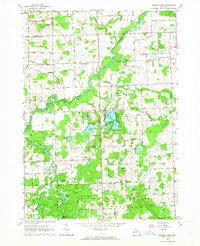
1963 Map of Barnes Lake
USGS Topo · Published 1964About this map
Barnes Lake and the surrounding wetlands of the Lapeer State Game Area dominate this central Michigan landscape in the early 1960s. The region is defined by its complex hydrology, where the North Branch Flint River and South Branch Flint River converge amidst a dense network of glacial lakes including Millers Lake, Norway Lake, and Dipper Lake. The map reveals a deeply established rural community, evidenced by several small country congregations like West Deerfield Ch, East Deerfield Ch, and the Deerfield Church of Christ. Education for these outlying farming districts was still anchored by localized schoolhouses such as Sweet Sch and Mills Sch. The prevalence of named drains, including the Fostoria Drain and Kester Drain, indicates an era of active agricultural land management, while the presence of an Oil Well and a Gravel Pit points to the local extraction economy found on the border of Tuscola and Lapeer counties.
Find a feature on this map
88 named features on this map. Tap any name to fly to it.
Don’t see what you’re looking for? This feature index may not catch every label — zoom into the map to look around manually.
Map Details
Editions of this 1963 Barnes Lake Map
2 editions found
Other maps of this area

1954 · Flint
USGS Topo · 1:250,000

1958 · Flint
USGS Topo · 1:250,000

1963 · Clifford
USGS Topo · 1:24,000

1963 · Attica
USGS Topo · 1:24,000

1963 · Mayville
USGS Topo · 1:24,000

1963 · North Branch
USGS Topo · 1:24,000

1963 · Columbiaville
USGS Topo · 1:24,000

1963 · Elba
USGS Topo · 1:24,000

1963 · Juniata
USGS Topo · 1:24,000
1963 · Lapeer
USGS Topo · 1:24,000
Featured Places
- Mayfield Township, MI
- Watertown Township, MI
- Oregon Township, MI
- Marathon Township, MI
- Rich Township, MI