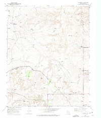
1953 Map of Cliffside
USGS Topo · Published 1975About this map
Cliffside Gas Field Camp sits at the heart of an active extraction landscape in the Texas Panhandle, where numerous gas wells dot the drainages of Horse Creek and West Amarillo Creek. This mid-century survey reveals a transition from traditional ranching to industrial utility, as the Fort Worth and Denver railroad cuts through the terrain. Evidence of early settlement is preserved in small family and community grounds like Townsend Cemetery and Arnot Cemetery, while the local economy is reflected in the presence of Wesley Dairy and Mc Collum Dairy. On the eastern edge, the Amarillo Rifle and Pistol Club Firing Range and small settlements like Gentry and Cliffside mark the expansion of Potter County's infrastructure. These details, including named locations such as Wilkins Ranch and Bishop Ranch, provide a clear picture of the land's utility and the families who worked it during the early 1950s.
Find a feature on this map
19 named features on this map. Tap any name to fly to it.
Don’t see what you’re looking for? This feature index may not catch every label — zoom into the map to look around manually.
Map Details
Editions of this 1953 Cliffside Map
3 editions found
Other maps of this area

1934 · Ady
USGS Topo · 1:62,500

1934 · Cliffside
USGS Topo · 1:62,500

1936 · Cliffside
USGS Topo · 1:62,500

1936 · Ady
USGS Topo · 1:62,500

1953 · Chunky
USGS Topo · 1:24,000

1953 · Puente
USGS Topo · 1:24,000

1953 · Pleasant Valley
USGS Topo · 1:24,000

1953 · Cliffside
USGS Topo · 1:24,000

1954 · Tucumcari
USGS Topo · 1:250,000

1954 · Amarillo
USGS Topo · 1:250,000