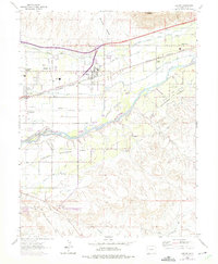
1962 Map of Clifton
USGS Topo · Published 1975About this map
Orchard Mesa and the surrounding agricultural valleys are defined by an intricate network of irrigation, with the Highline Canal, Price Ditch, and Stub Ditch feeding the landscape. The Colorado River meanders through the center of the sheet, creating the fertile Oldham Bottoms below the rising cliffs of Mount Garfield and Mount Lincoln. Transportation infrastructure is a dominant theme, as the Denver and Rio Grande Western railroad parallels the river, passing through Bridges Switch and providing a backbone for the area's development. Local life is centered around community landmarks like the East Orchard Mesa Community Hall and several rural congregations, including the Light and Life Chapel and the Central Orchard Mesa Community Ch. Settlement patterns show clusters of growth at Johnsons Corner and Fruitvale, while the IOOF Cem serves as a grounded point of local heritage.
Find a feature on this map
37 named features on this map. Tap any name to fly to it.
Don’t see what you’re looking for? This feature index may not catch every label — zoom into the map to look around manually.
Map Details
Editions of this 1962 Clifton Map
2 editions found
Other maps of this area

1955 · Cameo
USGS Topo · 1:24,000

1956 · Moab
USGS Topo · 1:250,000

1956 · Grand Junction
USGS Topo · 1:250,000

1959 · Grand Junction
USGS Topo · 1:250,000

1959 · Moab
USGS Topo · 1:250,000

1960 · Moab
USGS Topo · 1:250,000

1960 · Grand Junction
USGS Topo · 1:250,000

1962 · Moab
USGS Topo · 1:250,000

1962 · Grand Junction
USGS Topo · 1:250,000

1962 · Clifton
USGS Topo · 1:24,000