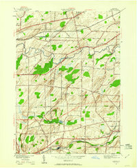
1950 Map of Clifton
USGS Topo · Published 1960About this map
Oatka Creek and Black Creek wind through this Monroe County landscape, defining the rural character of southwestern New York at mid-century. The map captures a transition as established hamlets like Clifton and Garbutt sit alongside growing academic and transportation hubs. Roberts Wesleyan College is prominent in the north, while the heavy rail infrastructure of the New York Central, West Shore, and Baltimore and Ohio railroads crisscrosses the terrain, meeting at strategic points like Chili Junction. Local genealogy is well-represented through numerous burial grounds, including the Quaker Cem and Fellows Cem. Distinctive landmarks such as the Airway Beacon and Blue Pond offer a detailed look at the 1950s geography of the Chili and Wheatland districts before later suburban expansion.
Find a feature on this map
61 named features on this map. Tap any name to fly to it.
Don’t see what you’re looking for? This feature index may not catch every label — zoom into the map to look around manually.
Map Details
Editions of this 1950 Clifton Map
Other maps of this area

1895 · Rochester
USGS Topo · 1:62,500

1898 · Rochester
USGS Topo · 1:62,500

1899 · Brockport
USGS Topo · 1:62,500

1901 · Honeoye
USGS Topo · 1:62,500

1904 · Caledonia
USGS Topo · 1:62,500

1904 · Honeoye
USGS Topo · 1:62,500

1912 · Rochester
USGS Topo · 1:62,500

1920 · Rochester
USGS Topo · 1:62,500

1931 · Rochester West
USGS Topo · 1:24,000

1932 · Spencerport
USGS Topo · 1:24,000