1973 Map of Clifton
USGS Topo · Published 1987About this map
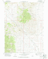
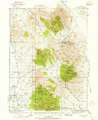
The Pony Express and Overland Stage Route cuts diagonally across this high-desert landscape in Tooele County, marking a corridor of deep historical significance. This 1973 survey details the rugged eastern slopes of the Clifton Hills, where the small settlement of Clifton sits near a cluster of early mining operations including the Monacco Mine and Midas Mine. A Historical Marker and the Canyon Sta (Ruins) further south provide tangible evidence of the overland travel infrastructure that once connected this remote region. High peaks such as Montezuma Peak, Young Peak, and Abercrombie Peak define the skyline, overlooking a series of canyons and gulches like Trippe Gulch and Bagley Gulch. These landforms directed early movement and prospecting, as evidenced by the numerous unnamed mines and the Overland Trail winding through North Canyon toward the broad expanse of Clifton Flat.
Find a feature on this map
42 named features on this map. Tap any name to fly to it.
Don’t see what you’re looking for? This feature index may not catch every label — zoom into the map to look around manually.
Map Details
Editions of this 1973 Clifton Map
2 editions found

Other maps of this area

1908 · Fish Springs
USGS Topo · 1:250,000

1910 · Fish Springs
USGS Topo · 1:250,000
1925 · Gold Hill
USGS Topo · 1:62,500

1928 · Gold Hill
USGS Topo · 1:62,500

1953 · Tooele
USGS Topo · 1:250,000

1953 · Delta
USGS Topo · 1:250,000

1955 · Tooele
USGS Topo · 1:250,000

1958 · Delta
USGS Topo · 1:250,000

1962 · Delta
USGS Topo · 1:250,000
1972 · Goshute Canyon
USGS Topo · 1:24,000