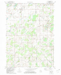
1982 Map of Climax
USGS Topo · Published 1982About this map
Climax serves as a central hub in this agricultural landscape on the border of Kalamazoo and Calhoun Counties. The village is characterized by its proximity to the Grand Trunk Western railroad line and local landmarks like the Radio Tower and a nearby Trailer Park. To the southeast, the small settlement of West Leroy is anchored by the West Leroy Cem and Leroy Ch, illustrating the traditional cluster of community life around rural intersections.
Find a feature on this map
39 named features on this map. Tap any name to fly to it.
Don’t see what you’re looking for? This feature index may not catch every label — zoom into the map to look around manually.
Map Details
Editions of this 1982 Climax Map
This is the sole edition of this map. No revisions or reprints were ever made.
Other maps of this area

1918 · Battle Creek
USGS Topo · 1:62,500

1918 · Union City
USGS Topo · 1:62,500

1918 · Galesburg
USGS Topo · 1:62,500

1918 · Leonidas
USGS Topo · 1:62,500

1943 · Battle Creek
USGS Topo · 1:62,500

1944 · Leonidas
USGS Topo · 1:62,500

1944 · Galesburg
USGS Topo · 1:62,500

1947 · Augusta
USGS Topo · 1:24,000

1947 · Galesburg
USGS Topo · 1:24,000

1947 · Battle Creek
USGS Topo · 1:24,000