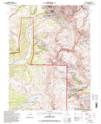
1994 Map of Climax
USGS Topo · Published 1998About this map
Climax stands as the primary industrial hub atop this high-altitude landscape, where the extraction of minerals has deeply shaped the terrain. This 1994 record, based on fieldwork from the mid-1990s, details an intricate mining economy evident in features like the Glory Hole and the extensive Tailings ponds near Fremont Pass. The map reveals how the industry integrated with the geography, showing a complex tramway and the London Tunnel alongside natural landmarks like Mount Democrat and Mount Arkansas.
Find a feature on this map
66 named features on this map. Tap any name to fly to it.
Don’t see what you’re looking for? This feature index may not catch every label — zoom into the map to look around manually.
Map Details
Editions of this 1994 Climax Map
This is the sole edition of this map. No revisions or reprints were ever made.
Other maps of this area

1889 · Leadville
USGS Topo · 1:125,000

1891 · Leadville
USGS Topo · 1:125,000

1934 · Climax
USGS Topo · 1:48,000

1935 · Mount Elbert
USGS Topo · 1:62,500

1938 · Mt. Lincoln
USGS Topo · 1:48,000

1938 · Mount Elbert
USGS Topo · 1:62,500

1939 · Mount Elbert
USGS Topo · 1:62,500

1942 · Leadville
USGS Topo · 1:125,000

1945 · Mount Lincoln
USGS Topo · 1:62,500

1949 · Holy Cross
USGS Topo · 1:62,500