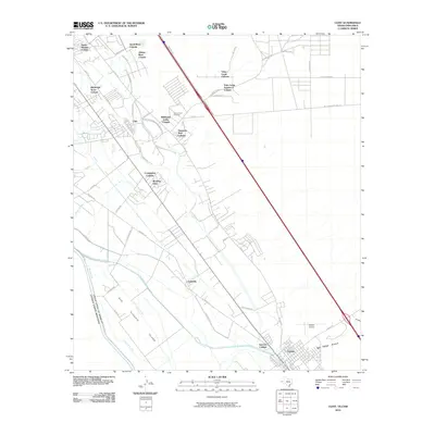
2010 Map of Clint
USGS Topo · Published 2010About this map
Clint and Fabens anchor this borderlands landscape where the irrigation networks of the Rio Grande valley meet the high desert. The map illustrates a dense collection of colonias, including Santa Martina Colonia, Wildhorse Valley Colonia, and Vista Larga Colonia, reflecting the unique residential development patterns of El Paso County. A complex system of water management is visible through the Riverside Canal, Franklin Canal, and Island Main Lateral, which transform the arid terrain of San Elizario Island. For genealogists and local historians, the San Lorenzo Cemetery and small communities like Morning Glory and Cuadrilla provide specific points of interest. The southern boundary of the map follows the international border with the United States of America and Mexico, following the winding path of the river and its adjacent drainage infrastructure like the Island Spur Drain.
Find a feature on this map
53 named features on this map. Tap any name to fly to it.
Don’t see what you’re looking for? This feature index may not catch every label — zoom into the map to look around manually.
Map Details
Editions of this 2010 Clint Map
This is the sole edition of this map. No revisions or reprints were ever made.
Other maps of this area

1896 · El Paso
USGS Topo · 1:125,000

1896 · Rio Grande
USGS Topo · 1:125,000

1908 · El Paso
USGS Topo · 1:125,000

1939 · Ysleta
USGS Topo · 1:62,500

1941 · Clint
USGS Topo · 1:62,500

1941 · Ysleta
USGS Topo · 1:62,500

1941 · Tornillo
USGS Topo · 1:62,500

1945 · Ysleta
USGS Topo · 1:62,500
1945 · Clint
USGS Topo · 1:62,500
1945 · Tornillo
USGS Topo · 1:62,500