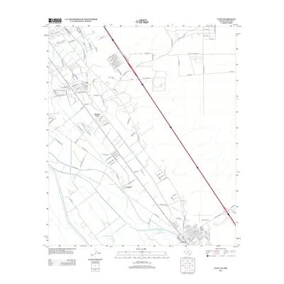
2012 Map of Clint
USGS Topo · Published 2012About this map
The Rio Grande valley southeast of El Paso is defined by a dense network of irrigation and drainage infrastructure, illustrating the region's managed agricultural landscape. Water control is the primary feature of the terrain, with the Riverside Canal and Riverside Intercepting Drain running parallel to the river, supported by numerous secondary channels like the Salatral Lateral and Rodriquena Lateral. These systems sustain a string of communities along the valley floor, from the established town of Clint down to Fabens.
Find a feature on this map
138 named features on this map. Tap any name to fly to it.
Don’t see what you’re looking for? This feature index may not catch every label — zoom into the map to look around manually.
Map Details
Editions of this 2012 Clint Map
This is the sole edition of this map. No revisions or reprints were ever made.
Other maps of this area

1896 · El Paso
USGS Topo · 1:125,000

1896 · Rio Grande
USGS Topo · 1:125,000

1908 · El Paso
USGS Topo · 1:125,000

1939 · Ysleta
USGS Topo · 1:62,500

1941 · Clint
USGS Topo · 1:62,500

1941 · Ysleta
USGS Topo · 1:62,500

1941 · Tornillo
USGS Topo · 1:62,500

1945 · Ysleta
USGS Topo · 1:62,500
1945 · Clint
USGS Topo · 1:62,500
1945 · Tornillo
USGS Topo · 1:62,500