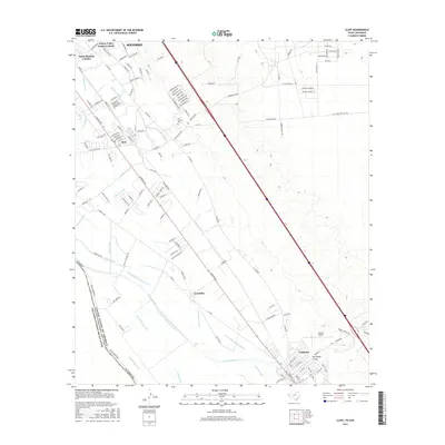
2016 Map of Clint
USGS Topo · Published 2016About this map
The Rio Grande forms the international boundary with Mexico along the southwestern edge of this El Paso County landscape, defining a fertile valley deeply etched by a complex irrigation network. This system, including the Riverside Canal and various laterals like the Salatral Lateral and Cuadrilla Lateral, supports the agricultural heritage of the communities of Socorro, Clint, and Fabens. The map captures a moment of residential expansion, evident in the development of the Santa Martina Colonia and Cotton Valley Estates Colonia near the northern boundary.
Find a feature on this map
141 named features on this map. Tap any name to fly to it.
Don’t see what you’re looking for? This feature index may not catch every label — zoom into the map to look around manually.
Map Details
Editions of this 2016 Clint Map
This is the sole edition of this map. No revisions or reprints were ever made.
Other maps of this area

1896 · El Paso
USGS Topo · 1:125,000

1896 · Rio Grande
USGS Topo · 1:125,000

1908 · El Paso
USGS Topo · 1:125,000

1939 · Ysleta
USGS Topo · 1:62,500

1941 · Clint
USGS Topo · 1:62,500

1941 · Ysleta
USGS Topo · 1:62,500

1941 · Tornillo
USGS Topo · 1:62,500

1945 · Ysleta
USGS Topo · 1:62,500
1945 · Clint
USGS Topo · 1:62,500
1945 · Tornillo
USGS Topo · 1:62,500