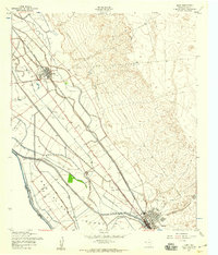
1955 Map of Clint
USGS Topo · Published 1959About this map
San Elizario Island sits at the heart of this mid-century survey, bordered by the Rio Grande and a complex network of irrigation works defining the borderlands of El Paso County. The settlements of Clint, Cuadrilla, and Fabens are oriented along the parallel corridors of the Texas and New Orleans (Southern Pacific) and Texas and Pacific railroads, which share the valley floor with the Jefferson Davis Highway. This landscape is heavily engineered for agriculture, featuring an intricate system of laterals and canals such as the Franklin Canal and Riverside Canal. Cultural landmarks reflect the era's social life, from the Rodeo Stadium in the northwest to a Drive-in Theater and the Fabens Airfield Under Construction near the southern edge of the quadrangle. Local genealogy is anchored by the San Lorenzo Cemetery and the presence of Camp Sch, illustrating the community infrastructure of the 1950s.
Find a feature on this map
54 named features on this map. Tap any name to fly to it.
Don’t see what you’re looking for? This feature index may not catch every label — zoom into the map to look around manually.
Map Details
Editions of this 1955 Clint Map
2 editions found
Other maps of this area

1896 · El Paso
USGS Topo · 1:125,000

1896 · Rio Grande
USGS Topo · 1:125,000

1908 · El Paso
USGS Topo · 1:125,000

1939 · Ysleta
USGS Topo · 1:62,500

1941 · Clint
USGS Topo · 1:62,500

1941 · Ysleta
USGS Topo · 1:62,500

1941 · Tornillo
USGS Topo · 1:62,500

1945 · Ysleta
USGS Topo · 1:62,500
1945 · Clint
USGS Topo · 1:62,500
1945 · Tornillo
USGS Topo · 1:62,500