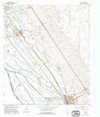
1995 Map of Clint
USGS Topo · Published 1995About this map
The Rio Grande serves as both a literal and political boundary in this 1995 revision, marking the border between the United States of America and Mexico. This section of the river valley is defined by an intricate network of irrigation and drainage infrastructure, including the Riverside Canal, Franklin Canal, and Island Drain, which support the agricultural life of San Elizario Island. The settlement patterns of Clint, Fabens, and Cuadrilla reflect the region's reliance on these water systems, with numerous feedlots and wells scattered throughout the lowlands. Local history and genealogy interest is concentrated around sites like the San Lorenzo Cemetery and various schools, including the High Sch in Clint and the Camp Sch Ball Park near Fabens. To the east, the terrain rises sharply from the valley floor toward a series of prominent peaks and canyons, including Arroyo San Felipe.
Find a feature on this map
49 named features on this map. Tap any name to fly to it.
Don’t see what you’re looking for? This feature index may not catch every label — zoom into the map to look around manually.
Map Details
Editions of this 1995 Clint Map
This is the sole edition of this map. No revisions or reprints were ever made.
Other maps of this area

1896 · El Paso
USGS Topo · 1:125,000

1896 · Rio Grande
USGS Topo · 1:125,000

1908 · El Paso
USGS Topo · 1:125,000

1939 · Ysleta
USGS Topo · 1:62,500

1941 · Clint
USGS Topo · 1:62,500

1941 · Ysleta
USGS Topo · 1:62,500

1941 · Tornillo
USGS Topo · 1:62,500

1945 · Ysleta
USGS Topo · 1:62,500
1945 · Clint
USGS Topo · 1:62,500
1945 · Tornillo
USGS Topo · 1:62,500