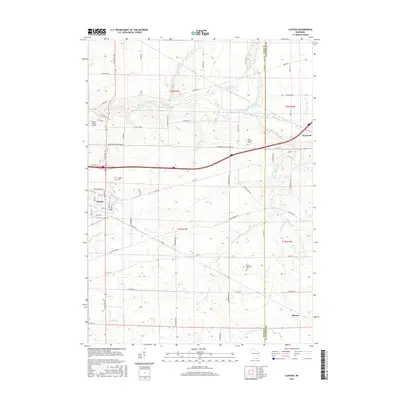
2016 Map of Clinton
USGS Topo · Published 2016About this map
Clinton serves as the primary hub of this southern Wisconsin landscape, situated where Spring Brook meets the local road network. The terrain is defined by the winding course of Turtle Creek and Little Turtle Creek, which carve through the farmland between the Rock and Walworth County line. This 2016 survey illustrates the modern layout of the village, including the proximity of Melin Farms Airport to the northwest. For those tracing local history, the map precisely locates several rural burying grounds, including Clinton Cem, Mount Phillips Cem, and Saint Catherine Cem. Smaller settlements such as Bardwell and the edge of Sharon are documented at the eastern margins, connected by a lattice of named rural routes like S O Riley Rd and Bradford-Clinton Town Rd. The drainage patterns of Dry Cr and Ladd Cr further reveal the natural hydrology of this agricultural region.
Find a feature on this map
67 named features on this map. Tap any name to fly to it.
Don’t see what you’re looking for? This feature index may not catch every label — zoom into the map to look around manually.
Map Details
Editions of this 2016 Clinton Map
This is the sole edition of this map. No revisions or reprints were ever made.
Other maps of this area

1893 · Delavan
USGS Topo · 1:62,500

1893 · Shopiere
USGS Topo · 1:62,500

1918 · Belvidere
USGS Topo · 1:62,500

1932 · Harvard
USGS Topo · 1:48,000

1937 · Harvard
USGS Topo · 1:62,500

1944 · Belvidere
USGS Topo · 1:62,500

1954 · Rockford
USGS Topo · 1:250,000

1955 · Rockford
USGS Topo · 1:250,000

1958 · Rockford
USGS Topo · 1:250,000
1960 · Delavan
USGS Topo · 1:62,500