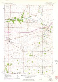
1961 Map of Clinton
USGS Topo · Published 1977About this map
The village of Clinton (Clinton Junction) serves as a central hub on this Rock County map, situated at a major rail intersection. The area’s geography is defined by the winding course of Turtle Creek and its tributaries, Spring Brook and Little Turtle Creek, which carve through the townships of Bradford, Clinton, Darien, and Sharon. The landscape is dotted with several rural cemeteries, such as Jefferson Prairie Cem and St Catherine Cem, providing significant touchpoints for genealogical research in this border region near the Wisconsin-Illinois line.
Find a feature on this map
31 named features on this map. Tap any name to fly to it.
Don’t see what you’re looking for? This feature index may not catch every label — zoom into the map to look around manually.
Map Details
Editions of this 1961 Clinton Map
This is the sole edition of this map. No revisions or reprints were ever made.
Other maps of this area

1893 · Delavan
USGS Topo · 1:62,500

1893 · Shopiere
USGS Topo · 1:62,500

1918 · Belvidere
USGS Topo · 1:62,500

1932 · Harvard
USGS Topo · 1:48,000

1937 · Harvard
USGS Topo · 1:62,500

1944 · Belvidere
USGS Topo · 1:62,500

1954 · Rockford
USGS Topo · 1:250,000

1955 · Rockford
USGS Topo · 1:250,000

1958 · Rockford
USGS Topo · 1:250,000
1960 · Delavan
USGS Topo · 1:62,500