
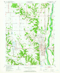
1951 Map of Clinton
USGS Topo · Published 1953About this map
The industrial and agricultural landscape of western Indiana is clearly defined by the Wabash River and a dense network of coal operations. In this mid-century survey, the town of Clinton serves as a central hub, flanked by mining-oriented settlements like Centenary and Klondyke. The prevalence of numerous labels for Strip Mine and a Gravel Pit indicates the region's heavy reliance on extraction during the early 1950s. Transportation is dominated by the Chicago Milwaukee St Paul and Pacific and the Chicago and Eastern Illinois railroads, which weave through the terrain to support local industry.
Find a feature on this map
48 named features on this map. Tap any name to fly to it.
Don’t see what you’re looking for? This feature index may not catch every label — zoom into the map to look around manually.
Map Details
Editions of this 1951 Clinton Map
2 editions found
Other maps of this area

1947 · Ridge Farm
USGS Topo · 1:62,500

1947 · Paris
USGS Topo · 1:62,500

1949 · Paris
USGS Topo · 1:62,500

1950 · Rosedale
USGS Topo · 1:24,000

1950 · New Goshen
USGS Topo · 1:24,000

1950 · Sandford
USGS Topo · 1:24,000

1951 · Mecca
USGS Topo · 1:24,000

1951 · Saint Bernice
USGS Topo · 1:24,000

1953 · Indianapolis
USGS Topo · 1:250,000

1955 · Scottland
USGS Topo · 1:24,000