
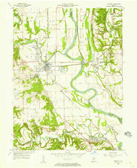
1955 Map of Scottland
USGS Topo · Published 1957About this map
Indian Reserve Boundary lines and interstate rail corridors define this mid-century survey of the Illinois-Indiana border. The landscape is marked by the crossroads of the Chicago Milwaukee St Paul and Pacific and the Baltimore and Ohio railroads, which facilitated the movement of goods through the small rural hubs of West Dana and Quaker. In the northern section, Jonathan Creek winds past early landmarks of local settlement, including the Hopewell Ch and Old Hopewell Cem. The presence of industrial Pipe Lines cutting through the agricultural sections of Helt and Vermillion townships illustrates the mid-century modernization of the region. Genealogists may find particular interest in the southern portion of the map, which includes the Bono Cem near the rail line at Randall.
Find a feature on this map
15 named features on this map. Tap any name to fly to it.
Don’t see what you’re looking for? This feature index may not catch every label — zoom into the map to look around manually.
Map Details
Editions of this 1955 Scottland Map
This is the sole edition of this map. No revisions or reprints were ever made.
Other maps of this area

1947 · Ridge Farm
USGS Topo · 1:62,500

1947 · Paris
USGS Topo · 1:62,500

1949 · Paris
USGS Topo · 1:62,500

1951 · Clinton
USGS Topo · 1:24,000

1951 · Saint Bernice
USGS Topo · 1:24,000

1953 · Indianapolis
USGS Topo · 1:250,000

1955 · Humrick
USGS Topo · 1:24,000

1955 · Dana
USGS Topo · 1:24,000
1955 · Newport
USGS Topo · 1:24,000

1956 · Indianapolis
USGS Topo · 1:250,000