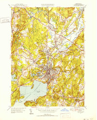
1950 Map of Clinton
USGS Topo · Published 1952About this map
The Wachusett Reservoir dominates the southern landscape of this 1950s survey, its northern shore defined by Cunningham Ledge and Tahanto Pt. The industrial and educational character of central Massachusetts is clearly evident, with the extensive Lancaster Mill Pond and Ponakin Mill situated along the banks of the Nashua River. In South Lancaster, the campus of Atlantic Union College stands as a focal point near several historic burial grounds, including St Johns Cem and Old Common Cem.
Find a feature on this map
81 named features on this map. Tap any name to fly to it.
Don’t see what you’re looking for? This feature index may not catch every label — zoom into the map to look around manually.
Map Details
Editions of this 1950 Clinton Map
4 editions found
Other maps of this area

1885 · Worcester
USGS Topo · 1:62,500

1886 · Worcester
USGS Topo · 1:62,500

1887 · Marlboro
USGS Topo · 1:62,500

1887 · Fitchburg
USGS Topo · 1:62,500

1889 · Marlboro
USGS Topo · 1:62,500

1889 · Fitchburg
USGS Topo · 1:62,500

1892 · Worcester
USGS Topo · 1:62,500

1893 · Fitchburg
USGS Topo · 1:62,500

1893 · Groton
USGS Topo · 1:62,500

1896 · Marlboro
USGS Topo · 1:62,500