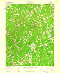
1957 Map of Clio
USGS Topo · Published 1960About this map
Osbornes Mills and the winding Big Sandy Creek define this rural landscape on the border of Roane and Kanawha counties during the late 1950s. The region is marked by an extensive network of small family cemeteries and country schoolhouses, such as Willow Grove Sch and Roadside Sch, indicating a dispersed but established community structure. Energy production is a visible layer of the local economy, with the Stringtown Oil Field and Mc Kown Creek Oil Field operating alongside a prominent Compressor Station and various pipelines. The terrain is characterized by distinctive formations like Jackson Rocks and Starcher Rocks, while social life centers on institutions like Camp Whitney and numerous churches, including Bethel Ch and Pine Grove Ch.
Find a feature on this map
110 named features on this map. Tap any name to fly to it.
Don’t see what you’re looking for? This feature index may not catch every label — zoom into the map to look around manually.
Map Details
Editions of this 1957 Clio Map
3 editions found
Other maps of this area

1897 · Kanawha Falls
USGS Topo · 1:125,000

1900 · Kanawha Falls
USGS Topo · 1:125,000

1901 · Kanawha Falls
USGS Topo · 1:125,000

1906 · Otter
USGS Topo · 1:62,500

1906 · Walton
USGS Topo · 1:62,500

1907 · Otter
USGS Topo · 1:62,500

1907 · Walton
USGS Topo · 1:62,500

1907 · Clendenin
USGS Topo · 1:62,500

1908 · Clay
USGS Topo · 1:48,000

1909 · Clendenin
USGS Topo · 1:62,500