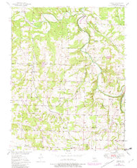
1950 Map of Cliquot
USGS Topo · Published 1982About this map
Flemington and the small siding of Cliquot anchor this mid-century look at Polk County, Missouri. The landscape is defined by the winding course of the Pomme De Terre River and its numerous tributaries, including Ashlock Creek and Davis Creek. Much of the river valley is preserved within the Pomme De Terre State Wildlife Management Area, while the Burlington Northern railroad cuts a north-south path through the western uplands.
Find a feature on this map
30 named features on this map. Tap any name to fly to it.
Don’t see what you’re looking for? This feature index may not catch every label — zoom into the map to look around manually.
Map Details
Editions of this 1950 Cliquot Map
2 editions found

Other maps of this area

1884 · Bolivar
USGS Topo · 1:125,000

1886 · Stockton
USGS Topo · 1:125,000

1892 · Bolivar
USGS Topo · 1:125,000

1942 · Elkton
USGS Topo · 1:24,000

1944 · Humansville
USGS Topo · 1:24,000

1949 · Elkton
USGS Topo · 1:24,000

1949 · Sentinel
USGS Topo · 1:24,000

1950 · Elkton
USGS Topo · 1:24,000

1950 · Sentinel
USGS Topo · 1:24,000

1950 · Polk
USGS Topo · 1:24,000