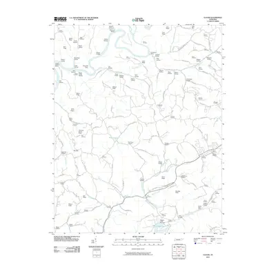
2010 Map of Clouds
USGS Topo · Published 2010About this map
The Powell River winds through this corner of Claiborne County, carving a landscape defined by sharp ridges and narrow hollows like Lonesome Valley and Hickory Hollow. The geography is dotted with family cemeteries and small-scale extractive sites, reflecting a long history of local land use. Mining activity is evident at the Straight Creek Mines and Kings Bend Mine, while geological exploration is marked by the Fortner Branch Prospect and Honeysuckle Prospect. In the southern reaches, the impounded waters of Big Ridge Lake and the Straight Creek Boat Dock suggest a shift toward recreational utility. The dense network of cemeteries, including the Water Treece Cemetery, Goin Cemetery, and Shiflet Cemetery, serves as a critical resource for genealogists tracing the kinship patterns of these Appalachian ridges.
Find a feature on this map
157 named features on this map. Tap any name to fly to it.
Don’t see what you’re looking for? This feature index may not catch every label — zoom into the map to look around manually.
Map Details
Editions of this 2010 Clouds Map
This is the sole edition of this map. No revisions or reprints were ever made.
Other maps of this area

1886 · Cumberland Gap
USGS Topo · 1:125,000

1888 · Cumberland Gap
USGS Topo · 1:125,000

1891 · Cumberland Gap
USGS Topo · 1:125,000

1897 · Maynardville
USGS Topo · 1:125,000

1900 · Maynardville
USGS Topo · 1:125,000

1903 · Middlesboro
USGS Topo · 1:48,000

1927 · Middlesboro
USGS Topo · 1:62,500

1930 · Middlesboro
USGS Topo · 1:62,500

1935 · Mingo Mountains
USGS Topo · 1:24,000

1935 · Cumberland Gap
USGS Topo · 1:24,000