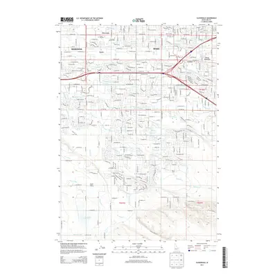
2013 Map of Cloverdale
USGS Topo · Published 2013About this map
Hubbard Reservoir anchors the southwestern portion of this Boise-area landscape, which in 2013 shows a complex transition from open space to suburban development. The map reveals an intricate irrigation network essential to Ada County, featuring the New York Canal, Ridenbaugh Canal, and Settlers Canal that traverse the territory alongside numerous smaller laterals. These waterways underscore the region's agricultural history even as newer settlements like Perkins and Beatty expand. Cultural and educational sites are prominent, including the Milan Institute, Apollo Coll, and the Univ of Phoenix-Idaho Campus. Local heritage and community hubs are noted through landmarks such as the Tenmile Rodeo Grounds and quiet spaces like Cloverdale Memorial Park and Terrace Lawn Cem, marking the evolving identity of this Treasure Valley corridor between Boise and Meridian.
Find a feature on this map
153 named features on this map. Tap any name to fly to it.
Don’t see what you’re looking for? This feature index may not catch every label — zoom into the map to look around manually.
Map Details
Editions of this 2013 Cloverdale Map
This is the sole edition of this map. No revisions or reprints were ever made.
Other maps of this area

1892 · Boise
USGS Topo · 1:125,000

1892 · Bisuka
USGS Topo · 1:125,000

1894 · Bisuka
USGS Topo · 1:125,000

1897 · Boise
USGS Topo · 1:125,000

1953 · Eagle
USGS Topo · 1:24,000

1953 · Cloverdale
USGS Topo · 1:24,000

1953 · Meridian
USGS Topo · 1:24,000

1953 · Star
USGS Topo · 1:24,000

1954 · Boise South
USGS Topo · 1:24,000

1954 · Boise North
USGS Topo · 1:24,000