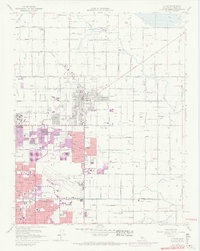
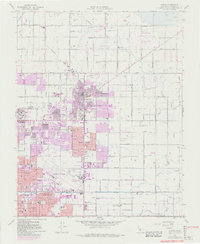
1964 Map of Clovis
USGS Topo · Published 1974About this map
The expansion of Clovis and Fresno is documented during this period of mid-century growth, as the suburban footprint moved eastward across the San Joaquin Valley. This 1964 survey, revised in 1972, highlights the transition from agricultural tracts to residential neighborhoods, with purple-tinted areas showing new development around Tarpey Village and the Calif State Univ Fresno campus. A complex network of irrigation infrastructure including the Enterprise Canal and Briggs Canal remains visible, reflecting the region's deep agricultural roots alongside newer industrial features like the Winery near Las Palmas.
Find a feature on this map
61 named features on this map. Tap any name to fly to it.
Don’t see what you’re looking for? This feature index may not catch every label — zoom into the map to look around manually.
Map Details
Editions of this 1964 Clovis Map
5 editions found
Other maps of this area

1921 · Bullard
USGS Topo · 1:31,680

1922 · Round Mountain
USGS Topo · 1:31,680

1922 · Lanes Bridge
USGS Topo · 1:31,680

1922 · Friant
USGS Topo · 1:31,680

1923 · Malaga
USGS Topo · 1:31,680

1923 · Academy
USGS Topo · 1:31,680

1923 · Fresno
USGS Topo · 1:31,680

1923 · Clovis
USGS Topo · 1:31,680

1923 · Sanger
USGS Topo · 1:31,680

1923 · Bullard
USGS Topo · 1:31,680