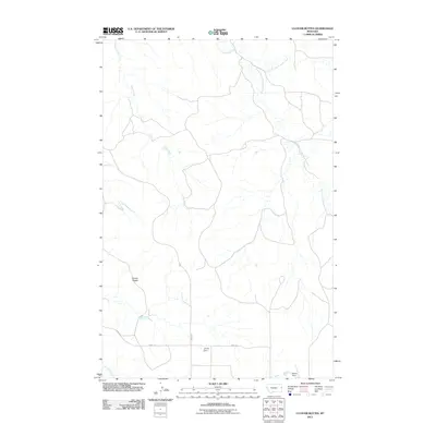
2011 Map of Cluster Buttes
USGS Topo · Published 2011About this map
Cluster Buttes rises above a landscape defined by the branching drainages of the Cottonwood Creek system and Castle Creek in Dawson County. This 2011 survey illustrates a sparsely populated region of eastern Montana, where human intervention is primarily represented by local water management and rural transit routes. The presence of Jet Set Dam and Blyton Dam suggests the importance of water storage in this arid drainage basin, serving local agricultural or ranching needs. Connectivity is maintained by a minimal network of thoroughfares, including Road 328 and the appropriately named River Rd, which skirts the lower drainages. The map provides a clear record of the area's hydrology, tracing the split between the North Fork Cottonwood Creek and South Fork Cottonwood Creek, as well as the path of Box Elder Creek near the southern margin.
Find a feature on this map
10 named features on this map. Tap any name to fly to it.
Don’t see what you’re looking for? This feature index may not catch every label — zoom into the map to look around manually.
Map Details
Editions of this 2011 Cluster Buttes Map
This is the sole edition of this map. No revisions or reprints were ever made.
Other maps of this area

1909 · Glendive
USGS Topo · 1:250,000

1954 · Glendive
USGS Topo · 1:250,000

1957 · Glendive
USGS Topo · 1:250,000

1958 · Glendive
USGS Topo · 1:250,000

1966 · Savage SE
USGS Topo · 1:24,000

1966 · Savage SW
USGS Topo · 1:24,000

1981 · Glendive
USGS Topo · 1:100,000
1982 · Cluster Buttes SW
USGS Topo · 1:24,000
1982 · Cluster Buttes SE
USGS Topo · 1:24,000
1982 · Odland Dam NW
USGS Topo · 1:24,000