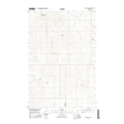
2017 Map of Cluster Buttes
USGS Topo · Published 2017About this map
Cluster Buttes rises as a prominent landmark within the high plains of Eastern Montana, straddling the boundary where Dawson and Wibaux counties meet. This 2017 survey reveals a landscape deeply carved by drainage systems, primarily the intermittent flows of Cottonwood Creek and its branches, including N Fork Cottonwood Cr and S Fork Cottonwood Cr. The map captures the intricate relief of the buttes and the surrounding coulees, illustrating how the terrain dictates the sparse infrastructure of this ranching country. Local transport is limited to a few improved paths such as Rd 328 and Rd 331, which navigate the draws between Castle Creek and Box Elder Creek. The lack of dense settlement emphasizes the vastness of the public and private lands situated along the township lines of t17n r58e and t16n r59e.
Find a feature on this map
14 named features on this map. Tap any name to fly to it.
Don’t see what you’re looking for? This feature index may not catch every label — zoom into the map to look around manually.
Map Details
Editions of this 2017 Cluster Buttes Map
This is the sole edition of this map. No revisions or reprints were ever made.
Other maps of this area

1909 · Glendive
USGS Topo · 1:250,000

1954 · Glendive
USGS Topo · 1:250,000

1957 · Glendive
USGS Topo · 1:250,000

1958 · Glendive
USGS Topo · 1:250,000

1966 · Savage SE
USGS Topo · 1:24,000

1966 · Savage SW
USGS Topo · 1:24,000

1981 · Glendive
USGS Topo · 1:100,000
1982 · Cluster Buttes SW
USGS Topo · 1:24,000
1982 · Cluster Buttes SE
USGS Topo · 1:24,000
1982 · Odland Dam NW
USGS Topo · 1:24,000