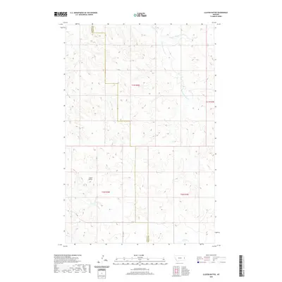
2020 Map of Cluster Buttes
USGS Topo · Published 2020About this map
Cluster Buttes dominate the southwestern landscape of this Dawson County region, marking a prominent upland area where the plains transition into complex drainage patterns. The terrain is defined by a network of seasonal watercourses, including the westward-flowing Box Elder Cr and the northern reaches of Castle Cr. Further north, the landscape is carved by the Cottonwood Cr system, where the N Fork Cottonwood Cr and S Fork Cottonwood Cr meet. This survey captures a rural Montana landscape shaped by the Public Land Survey System, with the boundary between Dawson County and Wibaux County cutting through the eastern sections. Minimal human infrastructure is present, limited primarily to local routes like Rd 328 and Rd 331, illustrating the sparse, ranch-oriented settlement patterns characteristic of the High Plains in the twenty-first century.
Find a feature on this map
13 named features on this map. Tap any name to fly to it.
Don’t see what you’re looking for? This feature index may not catch every label — zoom into the map to look around manually.
Map Details
Editions of this 2020 Cluster Buttes Map
This is the sole edition of this map. No revisions or reprints were ever made.
Other maps of this area

1909 · Glendive
USGS Topo · 1:250,000

1954 · Glendive
USGS Topo · 1:250,000

1957 · Glendive
USGS Topo · 1:250,000

1958 · Glendive
USGS Topo · 1:250,000

1966 · Savage SE
USGS Topo · 1:24,000

1966 · Savage SW
USGS Topo · 1:24,000

1981 · Glendive
USGS Topo · 1:100,000
1982 · Cluster Buttes SW
USGS Topo · 1:24,000
1982 · Cluster Buttes SE
USGS Topo · 1:24,000
1982 · Odland Dam NW
USGS Topo · 1:24,000