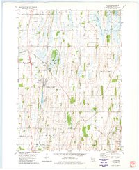
1980 Map of Clyman
USGS Topo · Published 1981About this map
Agricultural patterns and small-town intersections define the landscape around Clyman and Lebanon as documented in the late 1970s. The region is heavily marked by the infrastructure of the Chicago and North Western railroad, which meets at the local rail hub of Clyman Junction. The map provides significant genealogical value through its dense concentration of burial sites, including the Holy Assumption Cem, Clyman Center Cem, and Zion Cem, alongside smaller family or church plots such as Schmidt Cem and Fehling Cem. To the northeast, the shoreline of Sinissippi Lake transitions into wetlands fed by Dead Creek. These features illustrate a classic Wisconsin township structure where rural life centers on dispersed parish churches, local cemeteries, and transit points that once connected these farming communities to broader markets.
Find a feature on this map
40 named features on this map. Tap any name to fly to it.
Don’t see what you’re looking for? This feature index may not catch every label — zoom into the map to look around manually.
Map Details
Editions of this 1980 Clyman Map
This is the sole edition of this map. No revisions or reprints were ever made.
Other maps of this area

1891 · Waterloo
USGS Topo · 1:62,500

1892 · Watertown
USGS Topo · 1:62,500

1894 · Waterloo
USGS Topo · 1:62,500

1894 · Watertown
USGS Topo · 1:62,500

1910 · Waterloo
USGS Topo · 1:62,500

1955 · Beaver Dam
USGS Topo · 1:62,500

1955 · Horicon
USGS Topo · 1:62,500

1957 · Madison
USGS Topo · 1:250,000
1959 · Richwood
USGS Topo · 1:24,000

1959 · Ixonia
USGS Topo · 1:24,000