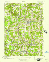
1939 Map of Clymer
USGS Topo · Published 1957About this map
The village of Sherman and the town of Clymer serve as the primary hubs in this agricultural and timber landscape of western Chautauqua County. This 1939 revision reflects a late Depression-era rural environment, where numerous crossroads settlements like Sheldon Corners, Wait Corners, and Marks anchored local life. The Pennsylvania railroad cuts through the terrain, connecting small stations such as Panama Sta and Jaquins to wider markets. Waterways define the topography, with French Creek and its branches winding through the valley floors, while Findley Lake stands out as a prominent natural feature to the west. Evidence of early twentieth-century rural education remains visible at Nettle Hill Sch, located between Summerdale and Sherman. The map provides a detailed view of the township boundaries for Ripley, Mina, and French Creek, documenting the property and infrastructure patterns established before mid-century modernization altered many of these smaller rural centers.
Find a feature on this map
43 named features on this map. Tap any name to fly to it.
Don’t see what you’re looking for? This feature index may not catch every label — zoom into the map to look around manually.
Map Details
Editions of this 1939 Clymer Map
4 editions found

Other maps of this area

1899 · Westfield
USGS Topo · 1:62,500

1900 · Dunkirk
USGS Topo · 1:62,500

1904 · Chautaqua
USGS Topo · 1:62,500

1905 · Clymer
USGS Topo · 1:62,500

1913 · North East
USGS Topo · 1:62,500

1915 · North East
USGS Topo · 1:62,500

1926 · Youngsville
USGS Topo · 1:62,500

1929 · Corry
USGS Topo · 1:48,000

1929 · Youngsville
USGS Topo · 1:62,500

1929 · Union City
USGS Topo · 1:62,500