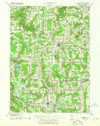
1939 Map of Clymer
USGS Topo · Published 1965About this map
The southwest corner of Chautauqua County was defined by an intricate network of rural crossroads and dairy farming communities as the 1930s drew to a close. This survey, revised from late-depression era aerial photography, shows the central settlement of Clymer as a local hub for the surrounding agricultural landscape. Transportation is dominated by the Pennsylvania railroad, which winds through the hills and connects depots like Panama Sta to the broader region.
Find a feature on this map
46 named features on this map. Tap any name to fly to it.
Don’t see what you’re looking for? This feature index may not catch every label — zoom into the map to look around manually.
Map Details
Editions of this 1939 Clymer Map
4 editions found

Other maps of this area

1899 · Westfield
USGS Topo · 1:62,500

1900 · Dunkirk
USGS Topo · 1:62,500

1904 · Chautaqua
USGS Topo · 1:62,500

1905 · Clymer
USGS Topo · 1:62,500

1913 · North East
USGS Topo · 1:62,500

1915 · North East
USGS Topo · 1:62,500

1926 · Youngsville
USGS Topo · 1:62,500

1929 · Corry
USGS Topo · 1:48,000

1929 · Youngsville
USGS Topo · 1:62,500

1929 · Union City
USGS Topo · 1:62,500