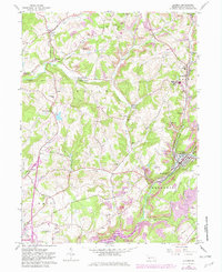
1963 Map of Clymer
USGS Topo · Published 1982About this map
The industrial and agricultural rhythms of Indiana County are recorded in this 1963 survey, updated with 1981 revisions. The borough of Clymer and the village of Dixonville stand as primary hubs along the rail corridors of the Penn Central and Baltimore and Ohio lines. The landscape is heavily marked by the region's extraction history, featuring numerous strip mines, a Quarry, and the Barr Slope mine site. These industrial features contrast with established rural landmarks like the Kintersburg Bridge and several country churches including Bethel Ch and Grove Chapel.
Find a feature on this map
59 named features on this map. Tap any name to fly to it.
Don’t see what you’re looking for? This feature index may not catch every label — zoom into the map to look around manually.
Map Details
Editions of this 1963 Clymer Map
4 editions found
Other maps of this area

1902 · Indiana
USGS Topo · 1:62,500

1902 · Barnesboro
USGS Topo · 1:62,500

1904 · Barnesboro
USGS Topo · 1:62,500

1906 · Punxsutawney
USGS Topo · 1:62,500

1909 · Smicksburg
USGS Topo · 1:62,500

1938 · Smicksburg
USGS Topo · 1:62,500

1939 · Smicksburg
USGS Topo · 1:62,500

1939 · Punxsutawney
USGS Topo · 1:62,500

1942 · Punxsutawney
USGS Topo · 1:62,500

1943 · Punxsutawney
USGS Topo · 1:125,000
Featured Places
- Rayne Township, PA
- Clymer, PA
- Dixonville, Green Township
- Tanoma, Rayne Township
- Gaiblton, Rayne Township