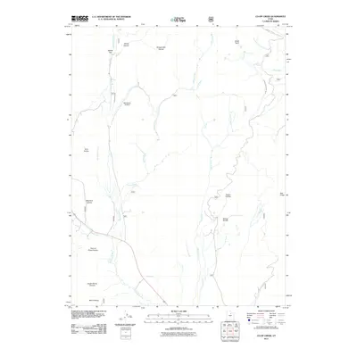
2011 Map of Co-op Creek
USGS Topo · Published 2011About this map
Strawberry River flows through this high-country landscape, serving as a central artery for a complex network of water management features including the Currant Creek Feeder Canal and Willow Creek Ditch. The terrain is defined by a succession of named canyons and hollows that speak to early resource use, such as Mill B Canyon, Shingle Mill Hollow, and Mill A Hollow, likely reflecting the area's history of timber harvesting and milling. The geography is further marked by significant basins and ridges, notably Smith Basin in the northeast and the distinctive Red Ledge to the east. From Point of Pines Canyon to Sugar Spring Canyon, the map reveals a rugged backcountry where water sources like Bull Spring were vital for the seasonal livestock grazing and forestry operations that have long characterized this part of Wasatch County.
Find a feature on this map
25 named features on this map. Tap any name to fly to it.
Don’t see what you’re looking for? This feature index may not catch every label — zoom into the map to look around manually.
Map Details
Editions of this 2011 Co-op Creek Map
This is the sole edition of this map. No revisions or reprints were ever made.
Other maps of this area

1885 · Salt Lake
USGS Topo · 1:250,000

1907 · Strawberry Valley
USGS Topo · 1:125,000

1909 · Strawberry Valley
USGS Topo · 1:125,000

1954 · Salt Lake City
USGS Topo · 1:250,000

1958 · Salt Lake City
USGS Topo · 1:250,000

1960 · Salt Lake City
USGS Topo · 1:250,000

1966 · Strawberry Reservoir NW
USGS Topo · 1:24,000
1966 · Strawberry Reservoir NE
USGS Topo · 1:24,000

1967 · Two Tom Hill
USGS Topo · 1:24,000
1967 · Center Creek
USGS Topo · 1:24,000