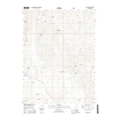
2014 Map of Co-op Creek
USGS Topo · Published 2014About this map
The Uinta National Forest dominates this section of the Wasatch Range, where complex mountain drainages define the high-country landscape. Water management is central to the area's geography, evidenced by the Strawberry River and the Willow Cr Ditch winding through the canyons. The map documents an intricate network of hollows and basins, such as Bjorkman Hollow and Smith Basin, which historically served as vital landmarks for grazing and early timber operations. Local toponyms like Shingle Mill Hollow and Mill A Hollow reflect the nineteenth-century industrial history of the canyon, pointing to early logging and milling sites that provided lumber for regional growth. Toward the south, the terrain descends into Sugar Spring Canyon and Point of Pines Canyon near the path of US Hwy 40, illustrating the intersection of natural watercourses and modern transportation corridors in the Utah highlands.
Find a feature on this map
38 named features on this map. Tap any name to fly to it.
Don’t see what you’re looking for? This feature index may not catch every label — zoom into the map to look around manually.
Map Details
Editions of this 2014 Co-op Creek Map
This is the sole edition of this map. No revisions or reprints were ever made.
Other maps of this area

1885 · Salt Lake
USGS Topo · 1:250,000

1907 · Strawberry Valley
USGS Topo · 1:125,000

1909 · Strawberry Valley
USGS Topo · 1:125,000

1954 · Salt Lake City
USGS Topo · 1:250,000

1958 · Salt Lake City
USGS Topo · 1:250,000

1960 · Salt Lake City
USGS Topo · 1:250,000

1966 · Strawberry Reservoir NW
USGS Topo · 1:24,000
1966 · Strawberry Reservoir NE
USGS Topo · 1:24,000

1967 · Two Tom Hill
USGS Topo · 1:24,000
1967 · Center Creek
USGS Topo · 1:24,000