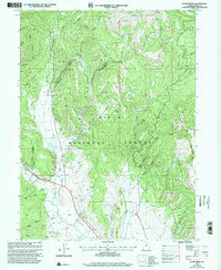
1998 Map of Co-Op Creek
USGS Topo · Published 2002About this map
The Uinta National Forest dominates this landscape, defined by a complex network of canyons and high-elevation creek basins. The Uintah Reservation Boundary cuts across the terrain, marking an important jurisdictional line amidst the rugged topography. Significant water features like the Strawberry River and Co-op Creek drain these slopes, while numerous Springs and landmarks such as Pines Point and Dock Flat offer specific reference points for navigating the backcountry.
Find a feature on this map
38 named features on this map. Tap any name to fly to it.
Don’t see what you’re looking for? This feature index may not catch every label — zoom into the map to look around manually.
Map Details
Editions of this 1998 Co-Op Creek Map
This is the sole edition of this map. No revisions or reprints were ever made.
Other maps of this area

1885 · Salt Lake
USGS Topo · 1:250,000

1907 · Strawberry Valley
USGS Topo · 1:125,000

1909 · Strawberry Valley
USGS Topo · 1:125,000

1954 · Salt Lake City
USGS Topo · 1:250,000

1958 · Salt Lake City
USGS Topo · 1:250,000

1960 · Salt Lake City
USGS Topo · 1:250,000

1966 · Strawberry Reservoir NW
USGS Topo · 1:24,000
1966 · Strawberry Reservoir NE
USGS Topo · 1:24,000

1967 · Two Tom Hill
USGS Topo · 1:24,000
1967 · Center Creek
USGS Topo · 1:24,000