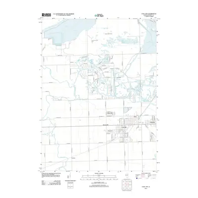
2012 Map of Coal City
USGS Topo · Published 2012About this map
Coal City and its neighboring communities of Carbon Hill, Eileen, and Diamond anchor this 2012 survey, illustrating the modern footprint of a region long defined by its industrial roots. The landscape is heavily marked by water management and conservation, with large reservoirs such as Heidecke Lake and the Dresden Cooling Lake adjacent to the natural flow of the Illinois River and Kankakee River. North of the residential clusters, the Goose Lake Prairie and Sand Ridge provide a look at the preserved natural terrain, while the residential layout of Harrisonville and the southern settlement at Gorman show the continued importance of the local road network, including E McArdle Rd and E Spring Rd. Genealogists will find the Holderman Cem and Short Cem clearly positioned, offering specific points of reference for family history research in this part of Grundy County.
Find a feature on this map
108 named features on this map. Tap any name to fly to it.
Don’t see what you’re looking for? This feature index may not catch every label — zoom into the map to look around manually.
Map Details
Editions of this 2012 Coal City Map
This is the sole edition of this map. No revisions or reprints were ever made.
Other maps of this area

1892 · Morris
USGS Topo · 1:62,500

1892 · Wilmington
USGS Topo · 1:62,500

1918 · Wilmington
USGS Topo · 1:62,500

1918 · Morris
USGS Topo · 1:62,500

1923 · Herscher
USGS Topo · 1:62,500

1925 · Herscher
USGS Topo · 1:62,500

1948 · Dwight
USGS Topo · 1:62,500

1950 · Dwight
USGS Topo · 1:62,500

1953 · Morris
USGS Topo · 1:24,000

1953 · Lisbon
USGS Topo · 1:24,000