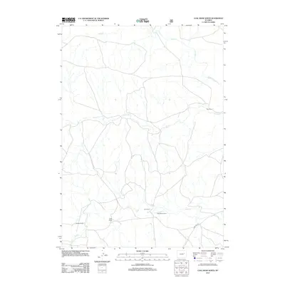
2012 Map of Coal Draw North
USGS Topo · Published 2012About this map
Coal Draw anchors this sparsely settled portion of Campbell County, Wyoming, as it appeared in the early 21st century. The landscape is characterized by a network of drainage systems including Bates Cr, Antelope Cr, and Sand Cr, which dictate the placement of ranching homesteads and access roads. The map reveals the vital importance of private infrastructure in this ranching country, where large landholdings like Stevic Ranch, Jenne Ranch, and Spracklen Ranch represent the primary human presence.
Find a feature on this map
9 named features on this map. Tap any name to fly to it.
Don’t see what you’re looking for? This feature index may not catch every label — zoom into the map to look around manually.
Map Details
Editions of this 2012 Coal Draw North Map
This is the sole edition of this map. No revisions or reprints were ever made.
Other maps of this area

1955 · Newcastle
USGS Topo · 1:250,000

1958 · Newcastle
USGS Topo · 1:250,000

1959 · Betty Reservoir
USGS Topo · 1:62,500

1959 · Coal Draw
USGS Topo · 1:62,500

1960 · Turnercrest
USGS Topo · 1:62,500

1971 · Teckla SW
USGS Topo · 1:24,000

1974 · Reno Junction
USGS Topo · 1:100,000

1979 · Bill
USGS Topo · 1:100,000

1984 · Turnercrest
USGS Topo · 1:24,000
1984 · Coal Draw North
USGS Topo · 1:24,000