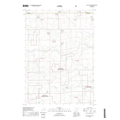
2018 Map of Coal Draw North
USGS Topo · Published 2018About this map
Thunder Basin National Grassland dominates this portion of the Powder River Basin, where the high plains of Campbell and Converse counties meet. The landscape is defined by its drainage systems, with Antelope Cr and Sand Cr cutting through the terrain alongside the namesake Coal Draw. While the region is largely open rangeland, human activity is marked by the presence of the Dilts Ranch Airport and water management features like the Betty Supply Ditch. This 2018 survey captures the intersection of public grazing lands and private ranching interests, providing a clear view of the rural infrastructure in one of Wyoming's most significant energy-producing regions. Local transit is limited to unpaved routes such as Jenne Trail Rd and Co Rd 34, which weave between Antelope Flat and Buck Draw.
Find a feature on this map
19 named features on this map. Tap any name to fly to it.
Don’t see what you’re looking for? This feature index may not catch every label — zoom into the map to look around manually.
Map Details
Editions of this 2018 Coal Draw North Map
This is the sole edition of this map. No revisions or reprints were ever made.
Other maps of this area

1955 · Newcastle
USGS Topo · 1:250,000

1958 · Newcastle
USGS Topo · 1:250,000

1959 · Betty Reservoir
USGS Topo · 1:62,500

1959 · Coal Draw
USGS Topo · 1:62,500

1960 · Turnercrest
USGS Topo · 1:62,500

1971 · Teckla SW
USGS Topo · 1:24,000

1974 · Reno Junction
USGS Topo · 1:100,000

1979 · Bill
USGS Topo · 1:100,000

1984 · Turnercrest
USGS Topo · 1:24,000
1984 · Coal Draw North
USGS Topo · 1:24,000