
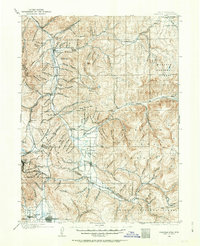
1900 Map of Coalville
USGS Topo · Published 1955About this map
Coalville serves as the regional hub at the turn of the century, positioned where the Union Pacific R.R. meets the waters of Chalk Creek and the Weber River. This 1899-1900 survey captures the high mountain valleys of Summit Co and Wasatch Co before the creation of modern reservoirs altered the landscape. To the south, the industrial influence of the mining district is evident near Park City, where the Ontario Drain Tunnel represents a massive engineering feat of the era.
Find a feature on this map
172 named features on this map. Tap any name to fly to it.
Don’t see what you’re looking for? This feature index may not catch every label — zoom into the map to look around manually.
Map Details
Editions of this 1900 Coalville Map
2 editions found
Other maps of this area

1885 · Salt Lake
USGS Topo · 1:250,000

1885 · Uinta
USGS Topo · 1:250,000

1901 · Hayden Peak
USGS Topo · 1:125,000

1903 · Hayden Peak
USGS Topo · 1:125,000

1903 · Coalville
USGS Topo · 1:125,000

1907 · Strawberry Valley
USGS Topo · 1:125,000

1909 · Strawberry Valley
USGS Topo · 1:125,000

1925 · Ft. Douglas
USGS Topo · 1:125,000

1928 · Ft. Douglas
USGS Topo · 1:125,000

1948 · Orem
USGS Topo · 1:62,500